
What you need to know about construction surveying:
 Before construction is started, thorough planning is carried out. Throughout the construction period a surveyor assists the work as necessary.
The surveyor keeps watch on reference points and establishes markers which steer the construction of all new improvements to the property.
For any help regarding construction surveying or staking, call Oklahoma City Land Surveying at (405) 546-2121 or send us a message by going here.

What is Construction Survey?
A Construction Survey is basically a survey that provides locations and points for construction activities; It can also assist the contractor in executing the work, evaluation of that work, and in estimation of quantities involved.
The initial construction survey is done to layout engineering and construction works. Measurements are done for reference points which determine the location of the planned structure or improvements, vertical and horizontal positioning, dimensions, configuration, and to control the elevation of the new structures.
Purpose
The purpose of doing a construction survey is to maintain and establish the necessary vertical and horizontal control distinctions needed for a construction project. It includes taking measurements which is mandatory to ascertain quantities, and then put these measurements in documentation to corroborate the final payments made to the contractor.
Post construction, the survey is used to assess the final position and adequacy of the work, and to compute construction payments and be able to establish “as built” conditions. The “As Built” survey is conducted as the construction work is finished to verify the work is according to the designs and plans.
Tasks that are involved in construction surveying are the following, generally in the order in which a construction survey is done:
Research, Reconnaissance, Control, and Mapping of the project area respectively are the tasks in this phase of an engineering project. This is a preliminary survey which is mainly the collection of data and establishing the survey control scheme that will be used during construction to “control” the position and elevation of each improvement. The result of this work is used for design, detailing of plans, and estimation of the project costs.
Gathering of the Design Data which include Project plans in digital and hard copies, Control Data (Vertical and Horizontal), Alignments (Vertical and Horizontal), New Roadway DTM, R/W data (with maps, descriptions and obligations), and Specifications.
 Field Work includes recovery of existing vertical and horizontal control, augmentation and replacement of control stations that are necessary to control the construction project, performing random checks of the vertical and horizontal control network, checking vertical controls as necessary, comparison of resultant coordinates to the original, collection of confidence points to check and validate the terrain model, condition documentation, and performing utility relocation surveys as necessary.
Finally, a Survey Drawing is done to illustrate how the completed improvements look and related to the design locations planned. The final piece that is presented after the tedious measurements and markings is also called a topographic surveymap which includes all of the vital features illustrated with the contours that represents the elevations.
Types of Surveys
Boundary Survey – is needed before beginning any type of construction. Knowing the limits of construction will save a lot of headaches in the end.
Site Plan – A site plan should have been prepared as construction is planned. This shows the layout of all the improvements on the piece of land and will guide their location. The majority of site plans are completed in the office. After approval of the site plan, then the construction staking can take place.
Topographic Survey – Again, this survey usually happens up front, but topo surveys may also be carried out during construction to provide quantities for payment on certain work items.
Elevation Survey – Performed to determine the elevation of a structure (house) and it’s relation to the floodplain. (See “elevation certificate” for more information.)
ALTA/ACSM Survey – This will probably be done at the end of the project for most commercial sites. This may also be called an As-Built survey
For any help regarding construction surveying or staking, call Oklahoma City Land Surveying at (405) 546-2121 or send us a message by going here.
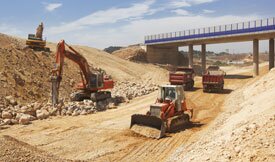
Highway surveying is a specialized type of construction surveying generally conducted for government agencies during either the planning and design stages of a highway project or during construction of the highway. During the construction process, a highway construction survey ensures that progress is occurring as it should, and that the highway is located where it should be. After the highway is built, an as-built highway survey is used to provide an accurate record of all built infrastructure.
 Surveyors are often called on during the early planning for the location of the highway. This requires a survey of the existing terrain to find the best route, areas where dirt must be moved, and the appropriate route where the least amount of land will need to be moved. An engineer can use the survey data to balance the earthwork on the project to reduce overall costs.
Once the earthwork is done, a surveyor will again check the grades and locations to ensure that the work has been done according to the plans. Before GPS technology, this involved surveying stakes to mark the road edges. Today, GPS has eliminated that process, making it easier to ensure that the road is aligned with the plans. Once the grading and leveling are verified by the surveyor, construction can continue.
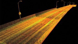
After the road is built, additional surveys may be required in the future. Accident surveys are also used during the process of accident reconstruction and investigations. Surveying while the road is open once required closing the entire road so that the survey team could set up equipment in the road. Today, laser scanning equipment allows this to be done from the roadside, eliminating the need for road or lane closures. The highly accurate data delivered by laser scanners allows the creation of detailed 3-D maps showing not only the roadway, but also barriers, overhead wires and other features.