
Aerial Survey for Documenting a Large Site Before Demolition Begins
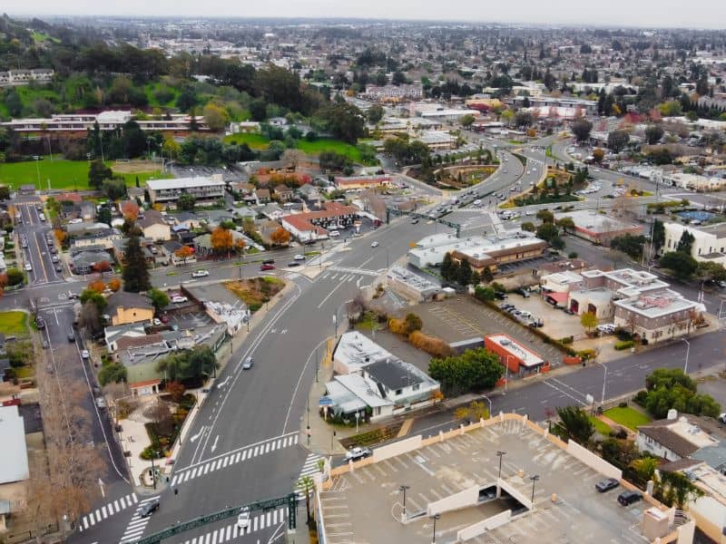
Once a building comes down, the record of what stood there goes with it. Old foundations, drainage paths, fence lines, and utility markers can vanish after a few days of heavy equipment work. That loss can cause trouble later, when a neighbor claims damage or a design team needs to know what was on the ground.
A pre-demolition aerial survey captures the whole property while it’s still intact. For developers and owners of large sites, it creates a dated, measurable baseline that contractors, engineers, and lenders can all use. Schedule the flight before any crews arrive, because that window closes fast.
Why Large Demolition Sites Need Accurate Pre-Demolition Documentation
Large sites carry more risk because there’s more to lose track of. A former shopping center, factory, or school campus may hold many buildings, parking lots, retaining walls, and service lines. Ground photos can miss a lot, and they rarely show how features relate to each other or to the property lines.
Good records protect the owner in practical ways. They show the condition of nearby buildings, roads, and sidewalks before vibration and truck traffic begin. They also help settle claims if a neighbor says a fence, driveway, or wall was damaged during the work.
Timing matters too. Once grading starts, the original ground surface and many site clues are gone for good. Permit offices, insurers, and lenders may ask for site records, and those needs can vary by project scope and municipality, so confirm them early.
What an Aerial Survey Captures Before Structures Are Removed
A drone or crewed aircraft flies a planned pattern and collects thousands of overlapping images. Some flights add LiDAR, a laser sensor that measures the ground even through light tree cover. Survey crews also set ground control points tied to known coordinates, which keeps the maps accurate.
From that data, a surveyor can produce several useful products. The right mix depends on what your project team needs now and what your engineer will ask for later. Common deliverables include:
An orthomosaic, which is one map-like image stitched from many photos
A surface model showing the heights of roofs, trees, and stockpiles
Ground contours that show slopes and drainage patterns
A 3D point cloud that can be measured from any angle
An aerial survey works best when it’s paired with ground work. Flights see roofs, pavement, and open ground clearly, but they can’t see inside buildings or under thick tree canopy. A field crew can fill those gaps by locating utility structures, monuments, and building corners.
Mapping Existing Site Features and Surrounding Property Conditions
The site itself is only half the picture. Demolition affects neighboring lots, public streets, sidewalks, and drainage ditches along the edges. Aerial mapping captures those areas in one consistent dataset, so before-and-after comparisons are easy to make.
On the property, the goal is to locate anything that affects removal work or future design. Some items will be torn out, and others will need protection. Typical mapped features include building footprints, retaining walls, fences, manholes, utility poles, curbs, driveway cuts, and drainage swales.
Boundaries need special care. An aerial survey can show where fences and pavement sit compared to recorded lines, but it doesn’t replace a boundary survey by a licensed surveyor. If there’s any doubt about where the property ends, ask for boundary work in the same project so demolition limits are clear.
Using Aerial Survey Data to Coordinate Demolition Planning
Demolition contractors plan around access, sequence, and hazards. A clear site map helps them choose haul routes, place equipment, and keep debris piles away from drainage paths. It also helps the owner mark what must be protected, such as a shared driveway or a utility easement.
Volume estimates are another big benefit. The surface model can show how much concrete, asphalt, or soil will leave the site. That helps contractors price the job, plan truck counts, and track progress.
Repeat flights add even more value. Many owners fly again after building removal and after final grading. Comparing each set of aerial survey data shows what changed and gives everyone a shared record for weekly meetings. Keep in mind that maps from the air won’t show buried lines, so utility locates and service disconnections still need to happen through the proper channels before work starts.
Preserving Survey Records for Future Site Development
Most large demolition projects lead to new construction. The design team will want to know where old foundations stood, how water drained, and where utilities entered the site. A well-kept record answers many of those questions before anyone has to dig or guess.
Ask your surveyor for files your engineer and architect can open, such as CAD drawings, georeferenced images, and point cloud files. Store them with the flight date, the coordinate system, and the surveyor’s name. That small step keeps the data useful for years, even if the property changes hands.
These records can also support a later topographic survey for site design or an ALTA survey for a lender or buyer. A pre-demolition aerial survey won’t replace those surveys, but it gives the next crew a strong starting point. It can also help explain site history during title review and due diligence.
Frequently Asked Questions
Why is an aerial survey useful before demolishing a large property?
It records the entire site quickly while every structure and feature is still in place. That baseline helps owners plan removal work, protect nearby property, and respond to damage claims. Ground photos rarely show how features relate across a large parcel. Once crews start work, that original condition is very hard to recreate.
What information can an aerial survey capture before demolition?
A typical flight captures detailed imagery, ground contours, building footprints, pavement, fences, and visible utility features. Some projects add LiDAR to measure ground under light tree cover. The data can also produce 3D models and volume estimates for debris and soil. Exact deliverables depend on project scope, so discuss them with your surveyor before the flight.
Can an aerial survey identify property boundaries before demolition?
Aerial mapping can show where fences, walls, and pavement sit, and it can overlay recorded lines on the image. It can’t legally establish a boundary on its own. A licensed surveyor still needs to research records and locate monuments in the field. If demolition limits run close to a neighbor, ask for boundary work as part of the project.
How does aerial survey documentation support demolition contractors?
Contractors use the maps to plan haul routes, equipment staging, and the order of removal. Surface models help estimate how much material will leave the site, which supports pricing and truck scheduling. Repeat flights let them track progress and share clear updates. The baseline images also show what conditions looked like before they started.
Can pre-demolition aerial survey data be used for future redevelopment?
Yes, and that’s one of the best reasons to fly the site. Designers can use the records to find old foundations, past drainage paths, and former utility entry points. The data often gives a head start on topographic work for new construction. Keep the files organized with the flight date and coordinate system so the next team can use them.
